Количество страниц: 2 с.
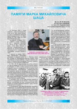
Шепелев, В. В.
Памяти Марка Михайловича Шаца / В. В. Шепелев, Ю. В. Шумилов, И. И. Сыромятников // Наука и техника в Якутии. - 2024. - N 2 (47). - C. 115-116. - DOI: 10.24412/1728-516Х-2024-2-115-116
DOI: 10.24412/1728-516Х-2024-2-115-116
Количество страниц: 11 с.
In recent years, forest fires have demonstrated an increasing trend in Yakutia, associated with modern global warming and extensive activation of cryogenic processes. In Central Yakutia, an ice complex is widespread, confined to the inter-alas type of terrain. Thawing of the ice component of the soils leads to the development of thermokarst, which is observed in disturbed treeless areas. The general climatic conditions, lithological and geocryological characteristics of the areas for which numerical modeling of the thermal state of soils was performed are described. The thermal state of inter-alas soils in 8 areas after forest fires was modeled during vegetation restoration, taking into account the current trend of increasing air temperature by 0.02о/year. The models were compiled for key periods of change in surface conditions and vegetation: 3, 8, 10 and 25 years after forest fires. It was revealed that in the Pokrovsk, Borogontsy and Berdigestyakh areas, it is possible to reach the depth of thawing of the ice horizon, which is due to high mean annual air temperatures and the spread of sandy loam in the upper part of deposits. And if the vegetation is not restored within the first three years, then presumably cryogenic processes will occur in these areas. In other areas, according to the modeling results, thawing does not reach the ice complex; gradual self-restoration of vegetation should bring geocryological conditions to their original state within 20-25 years. Soil temperatures are expected to rise, which is related to the current general warming of the climate. If the warming trend continues, thawing and soil temperature increases will be more significant and noticeable.
Новоприезжая, В. А.
Расчетные геокриологические характеристики межаласий после лесных пожаров в Центральной Якутии / В. А. Новоприезжая, А. Н. Федоров ; Институт мерзлотоведения им. П. И. Мельникова // Вестник Северо-Восточного федерального университета им. М. К. Аммосова. Серия "Науки о Земле". - 2025. - N 3 (39). - С. 67-77. - DOI: 10.25587/2587-8751-2025-1-67-77
DOI: 10.25587/2587-8751-2025-1-67-77
Количество страниц: 12 с.
Currently, the problem of reducing the efficiency of reservoir pressure maintenance systems at late stages of field development with highly heterogeneous reservoirs is a serious one for the oil and gas industry. This paper considers the Srednebotuobinskoye oil and gas condensate field (SBNGKM), which is characterized by highly heterogeneous reservoir, water cut in some wells exceeding 95%, and low water injection efficiency. In this paper, waterflooding optimization using the streamline method was applied for the first time for the conditions of one of the largest fields in Yakutia – SBNGKM. The objective of the work was to increase the efficiency of reservoir pressure maintenance by redistributing injection between injection wells using hydrodynamic modeling of streamlines. The research materials included a three-dimensional hydrodynamic model of the Bt formation of the SBNGKM central block in the tNavigator software, historical data on 37 production and 15 injection wells for the period 2010-2021. An algorithm for redistributing injection with an increase in volumes in highly efficient wells by 20-30% and a decrease in low-efficiency wells by 15–40% was implemented. The results showed an increase in average injection efficiency by 41%, a decrease in water cut by 3.2% and an increase in cumulative oil production by 65,414 tons over a 10-year forecast period. Practical significance is confirmed by an increased ultimate oil recovery factor by 1.7% without capital expenditures. The prospects of the study are associated with the development of adaptive algorithms for automatic optimization based on machine learning and the integration of real monitoring systems for filtration parameters. The implementation of the proposed methodology can significantly increase the economic efficiency of developing complex reservoirs at a late stage of operation due to the rational use of the existing well infrastructure and water resources.
Томский, К. О.
Оптимизация заводнения Среднеботуобинского НГКМ на основе гидродинамического моделирования линий тока / К. О. Томский, М. С. Иванова, В. В. Егоров ; Северо-Восточный федеральный университет им. М. К. Аммосова // Вестник Северо-Восточного федерального университета им. М. К. Аммосова. Серия "Науки о Земле". - 2025. - N 3 (39). - С. 55-66. - DOI: 10.25587/2587-8751-2025-1-55-66
DOI: 10.25587/2587-8751-2025-1-55-66
Количество страниц: 11 с.
This paper focuses on building a digital model that reflects the variability of the physical and mechanical properties of the Elginskoye deposit. The initial data came from electronic databases compiled from geological and operational exploration reports. The Orange software package was used to create a geological model of the coal-bearing rock mass of the Elginskoye deposit. Block 3D models of the variability of physical and mechanical properties such as compressive strength, tensile strength, and density of carbon-bearing rocks in stratigraphic intervals at depths U6–U5, U5–U4, U4–H16, and H16–H15 were constructed. Modern computer technologies are able to visualize the values of physical and mechanical properties corresponding to each point of a two-dimensional cross-section of a geological body. Rather than constructing a complete three-dimensional digital model to assess the structure and condition of the rock mass, an approximation can be constructed using two-dimensional cross-sections, which clearly and informatively display the spatial variability of one of the physical and mechanical properties. An example is given of hypsometric plans for the distribution of rock strength under tension, compression, and bulk density at the depth of the surrounding rocks, in the interlayers U6–U5. Interlayer strength was measured at intervals ranging from 0.4 m to 1 m in depth, thereby identifying changes in the physical and mechanical properties of the rock both with depth and laterally. The presented plans demonstrate a significant variability in the strength and density properties of the rock. The strength limit of rocks under uniaxial compression, within the studied intervals, varies from 20.5 MPa to 129.9 MPa, the strength limit under uniaxial tension, from 2.64 MPa to 11.3 MPa, and the bulk density varies from 2.45 g/cm3 to 2.81 g/cm3. The results of the research can be used to design and plan the development of the deposit, as well as to draw up specifications for drilling and blasting operations, taking into account the variability of the properties of carbon-bearing rocks.
Малинин, Ю. А.
Цифровая модель как инструмент прогноза пространственной изменчивости физико-механических свойств углепородного массива / Ю. А. Малинин, Н. Н. Гриб ; Технический институт (филиал) Северо-Восточного федерального университета им. М. К. Аммосова, Тихоокеанский государственный университет // Вестник Северо-Восточного федерального университета им. М. К. Аммосова. Серия "Науки о Земле". - 2025. - N 3 (39). - С. 33-43. - DOI: 10.25587/2587-8751-2025-1-33-43
DOI: 10.25587/2587-8751-2025-1-33-43
Количество страниц: 6 с.
- Общий отдел > Организации и прочие типы объединений. Ассоциации. Конгрессы. Выставки. Музеи,
- Математика. Естественные науки > Общая геология . Метеорология. Климатология. Историческая геология. Стратиграфия. Палеогеография,
- НАУКА ЯКУТИИ > ОБЩИЙ ОТДЕЛ > Организации и прочие типы объединений. Ассоциации. Конгрессы. Выставки. Музеи,
- НАУКА ЯКУТИИ > МАТЕМАТИКА. ЕСТЕСТВЕННЫЕ НАУКИ > Геология. Геологические и геофизические науки.
- 1. Колодезников Игорь Иннокентьевич. Впечатления об удивительной книге
- 2. Лепов Валерий Валерьевич, Пудов Алексей Григорьевич. Идеология и будущее Республики Саха (Якутия) в государстве-цивилизации
- 3. Балакшин Георгий Дмитриевич. О якутском цикле стихотворений Евгения Евтушенко
- 4. Алексеев Владимир Романович. Холод и жизнь
- 5. Семенова Варвара Васильевна. Воссоздание традиционного кисломолочного продукта тара народа саха в современных условиях
- 6. Слодкевич Евгений Яковлевич, Находкин Николай Александрович. Совершенствование системы информирования населения о ЧС в Якутии на основе коротковолновой радиосвязи
- 7. Черосов Михаил Михайлович, Алексеева Ньургустана Михайловна. К 110-летию Георгия Павловича Коротова
- 8. Чаунина Наталья Владимировна. Итоги международной научно-практической конференции молодых учёных, аспирантов и студентов в г. Нерюнгри
- 9. Лепов Валерий Валерьевич, Голых Роман Николаевич. Конференция по математическому моделированию и автоматизации в наукограде Бийске
- 10. Кершенгольц Борис Моисеевич. О наиболее эволюционно древней рецепторно-регуляторной водосодержащей системе в организмах многоклеточных
- 11. Жукова Людмила Николаевна. Шаманские традиции лесных юкагиров в конце XIX – конце XX вв.
- 12. Киселев Валерий Васильевич. О становлении горной науки в Якутии
- 13. Данилова Вера Софроновна. Некоторые аспекты методологии исследования произведений искусства
- 14. Лепов Валерий Валерьевич. Международные усилия в области создания умных материалов
- 15. Николин Евгений Георгиевич. Незабудка Чекановского: история одной из таксономических загадок
- 16. Находкин Николай Александрович. Где находится земля Санникова?
- 17. Наука и техника в Якутии, 2024, №2 (47)
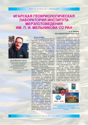
Сериков, С. И.
Игарская геокриологическая лаборатория Института мерзлотоведения им. П. И. Мельникова СО РАН / С. И. Сериков ; Игарская геокриологическая лаборатория Института мерзлотоведения им. П. И. Мельникова СО РАН // Наука и техника в Якутии. - 2024. - N 2 (47). - C. 20-25. - DOI: 10.24412/1728-516Х-2024-2-20-25
DOI: 10.24412/1728-516Х-2024-2-20-25
Количество страниц: 20 с.
- Общественные науки. Образование > Государственное административное управление. Военное дело,
- Математика. Естественные науки > Экономическая геология. Месторождение полезных ископаемых,
- НАУКА ЯКУТИИ > ОБЩЕСТВЕННЫЕ НАУКИ > Государственное административное управление. Военное дело,
- НАУКА ЯКУТИИ > МАТЕМАТИКА. ЕСТЕСТВЕННЫЕ НАУКИ > Геология. Геологические и геофизические науки,
- КНИГАКАН > Общественные науки > Политика. Экономика. Народное хозяйство,
- КНИГАКАН > Общая биология. Природа. Окружающая среда. Экология. Флора и фауна.
The supply of petroleum products and foodstuffs to the territories of the North and the Arctic is an important component of maintaining proper functioning and life support, and is of strategic importance for the economy of the Republic of Sakha (Yakutia). Because of high transportation costs and complex logistics, the activities of companies involved in the delivery of products within the framework of the northern importation are fraught with great difficulties and financial costs, and their risks are multiplied. The purpose of this study is to identify the factors that have the most significant impact on the financial position and sustainability of Sakhaneftegazsbyt JSC, which is responsible for the delivery of petroleum products and fuel to the north of the republic. The main research methods chosen in this case are economic and financial analysis. The results of the research have shown that because of the specific features of business activity, giving rise to a large duration of sales of current assets, Sakhaneftegazsbyt JSC is inevitably forced to attract borrowed capital in significant amounts. Because of this, the financial stability of the company is reduced and risks of insolvency arise. The situation is compounded by the growth of the key rate and the corresponding increase in the cost of commercial loans. In case the company’s financial situation gets worse, it would certainly receive state support sufficient to overcome the crisis situation. However, the expansion of opportunities for providing loans to organisations in charge of northern imports on favourable terms would avoid the need for such a support at all.
Ноева, Е. Е.
Проблемы финансового обеспечения организации-поставщика нефтепродуктов в рамках северного завоза / Е. Е. Ноева, А. Э. Мукамбетова ; Северо-Восточный федеральный университет им. М. К. Аммосова, Финансово-экономический институт // Арктика. XXI век. - 2024. - N 4 (38). - С. 41-60. - DOI: 10.25587/2310-5453-2024-4-41-60
DOI: 10.25587/2310-5453-2024-4-41-60
Количество страниц: 2 с.
- Общественные науки. Образование > Экономика. Экономические науки. Политическая экономия > Финансы. Банковское дело. Деньги и денежное обращение,
- Математика. Естественные науки > Экономическая геология. Месторождение полезных ископаемых,
- НАУКА ЯКУТИИ > ОБЩЕСТВЕННЫЕ НАУКИ > Экономика. Экономические науки. Политическая экономия,
- НАУКА ЯКУТИИ > МАТЕМАТИКА. ЕСТЕСТВЕННЫЕ НАУКИ > Геология. Геологические и геофизические науки.
- 1. Молодые специалисты о проблемах финансово-экономического развития Республики Саха (Якутия): материалы научной конференции студентов финансово-экономического института Якутского государственного университета им. М. К. Аммосова
Вып. 2, Вып. 2, 2006 - 2. Аверенская Н. Г. . Учёт и анализ расчётов с бюджетом по налогу на добавленную стоимость и управление обязательствами предприятия
- 3. Архипова Н. М.. Сравнительный анализ себестоимости рейсов, выполняемых на двух типах авиалайнеров ОАО АК "Якутия"
- 4. Егорова А. И.. Формирование цены на муку высшего сорта завезенного для обеспечения нужд социальной сферы и населения: на примере ГУП РС(Я) "Якутгосоптторг"
- 5. Захарова М. Ф.. Исследование структуры внеоборотных активов сельско-хозяйственного потребительского кооператива "Чурапча" и факторы его активизации
- 6. Брызгаева В. И.. Оценка эффективности государственного регулирования цен по производству, переработке, сбыту зерна и вырабатываемой из него готовой продукции: на примере ОАО "Сахазернопродукт"
- 7. Тасова А. Н.. Влияние налоговой системы на экономическое развитие страны
- 8. Лилло О. В.. Оптимизация налоговой нагрузки как ресурс повышения эффективности экономики
- 9. Спиридонов Н. И.. Особенности налогообложения коммерческих банков в PC(Я): на примере КБ "Таатта"
- 10. Шимко Т. В.. Исследование собираемости налогов и сборов по г. Якутску
- 11. Емельянова Н. Ю.. Исследование системы налогообложения использование природных ресурсов и пути ее совершенствования
- 12. Осипова А. П.. Упрощённая система налогообложения: выбор оптимального объекта налогообложения
- 13. Находкина А. И.. Особенности налогообложения малых предприятий на примере МП Аптеки N 55
- 14. Михайлов Р. Д. . Анализ налогообложения налога на доходы физических лиц: на примере предприятий Хангаласского улуса РС(Я)
- 15. Козлова Е. А.. Современная система налогообложения имущества предприятий
- 16. Алексеева Л. В.. Анализ типичных налоговых правонарушений допускаемых налогоплательщиками г. Якутска и разработка рекомендаций по их устранению
- 17. Кычкина О. Е.. Анализ налогообложения доходов физических лиц: на примере ГУ Управление физической культурой и массового спорта
- 18. Аргылова Л. В.. Оптимизация налоговой политики
- 19. Александрова Н. Д.. Исследование налоговой нагрузки на предприятии в строительной отрасли: на примере ООО ИСК "Сирстрой"
- 20. Иванова Л. С.. Анализ расчетных операций для оптимизации финансового состояния предприятия: на примере ОАО "Сахаэнерго"
Спиридонов, С. В.
Анализ платежей налога на добычу полезных ископаемых : на примере ОАО "Ленанефтегаз" / С. В. Спиридонов ; Якутский государственный университет им. М. К. Аммосова, Финансово-экономический институт // Молодые специалисты о проблемах финансово - экономического развития Республики Саха (Якутия) : материалы научной конференции студентов финансово-экономического института Якутского государственного университета им. М. К. Аммосова. - Вып. 2. - 2006. - 220, [4] с. : ил. - С. 91-92.

Издательство: Якутское государственное издательство
Год выпуска: 1942
Серия, номер выпуска: Вып. 1
Количество страниц: 110 с.
- Великая Отечественная война. Якутия в 1941-1945 гг. > Книги, изданные в годы войны,
- Общий отдел > Общие вопросы науки и культуры,
- Математика. Естественные науки > Общая геология . Метеорология. Климатология. Историческая геология. Стратиграфия. Палеогеография,
- НАУКА ЯКУТИИ > МАТЕМАТИКА. ЕСТЕСТВЕННЫЕ НАУКИ > Геология. Геологические и геофизические науки.
Исследование вечной мерзлоты в Якутской республике. - Якутск : Якутское государственное издательство, 1942- . Вып. 1. - 1942. - 102 с.

Ответственность: ответственный редактор В. М. Пигузова
Издательство: ИМ СО РАН
Год выпуска: 1992
Количество страниц: 58 с.
Григорьев, Николай Филиппович.
Мерзлотно-гидрогеологические особенности района г. Игарки / Н. Ф. Григорьев ; ответственный редактор к.геогр.н. В. М. Пигузова ; Российская академия наук, Сибирское отделение, Институт мерзлотоведения. - Препринт. - Якутск : ИМ СО РАН, 1992. - 55, [1] с.

Издательство: Якутское государственное издательство
Год выпуска: 1950
Серия, номер выпуска: Вып. 2
Количество страниц: 244 с.
Исследование вечной мерзлоты в Якутской республике. - Якутск : Якутское государственное издательство, 1942- . Вып. 2. - 1950. - 235 с.